|
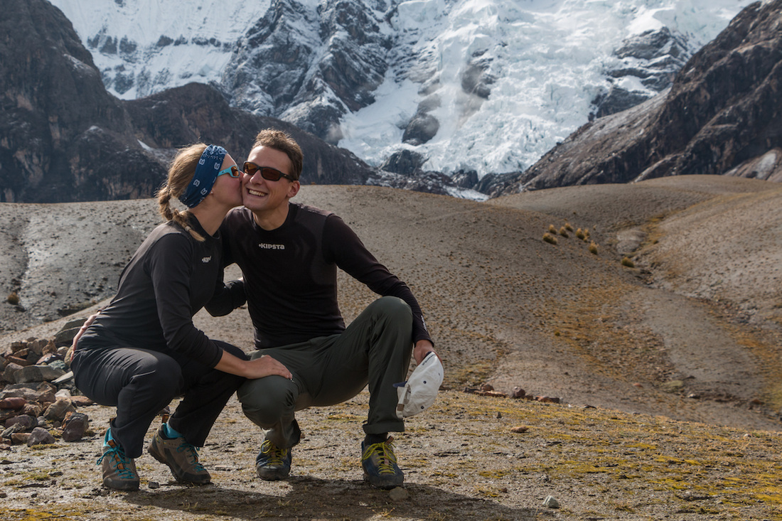
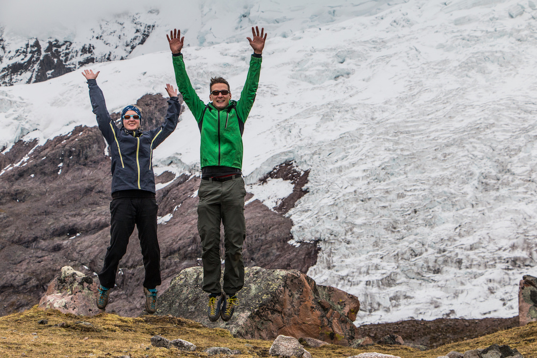
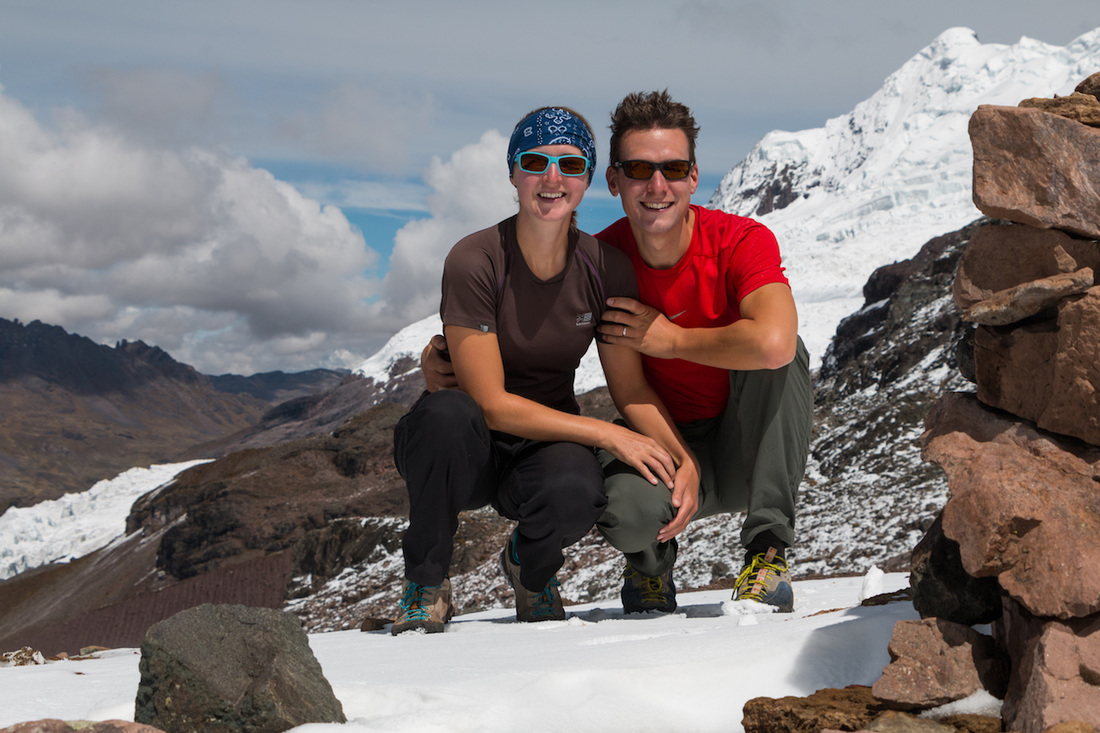
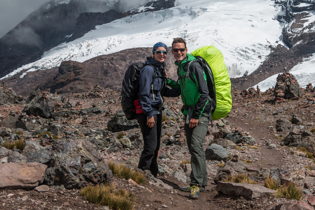
The Ausangate Trek is definitely the most beautiful trek we have ever made and surely the highlight of our time in Peru! We marched within breathtaking landscape, climbed four high passes, camped at remote sites with vistas on a laguna or over a plain of herding alpacas, we awed at colorful rocks or felt very humble beneath wide ice fields and glaciers. The trek around Nevado Ausangate covers roughly 65 km and is usually hiked in five days. It is said to be the highest trek in Peru as most of the trail is above 4000 m (the highest pass is at 5150 m), which naturally results in low temperatures, especially during the nights. 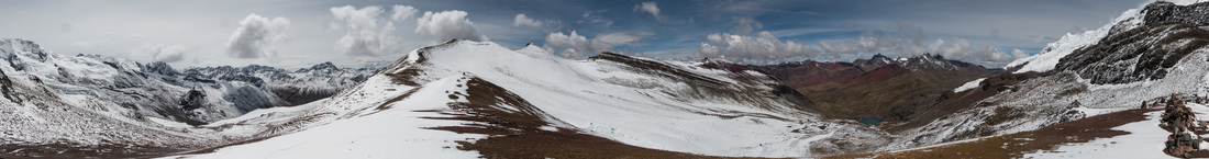 We read on a few blogs, that the trek is supposed to be difficult and tough. For us, we did not encounter any difficulties, however we planned our routing carefully and always tried to start hiking in the early morning, as at this time of the year heavy showers are common in the afternoon. We perceived the trail as moderate (we could hike it easily in our trekking shoes), the climbs were gradual and only occasionally there was a steep slope. One needs to be in good shape and of course well acclimatized, because of the constant high altitude (also for sleeping). We didn't have any problems with the altitude, maybe also because we were eating Coca toffees while climbing :-). Our GPS, though, was extremely helpful, as sometimes the track was lost or altered due to the landscape (there are many marsh districts). We decided to trek solo and therefore made the sacrifice to carry our equipment and food for five days with us. It was totally worth the effort, as one of the most beautiful facts about this trek is that you are basically alone for the entire time. We only passed some shepherds, camped next to one guided tour during the first night and met one other couple at the Palomani peak that also trekked independently. We will never forget the vastness, wilderness and rough beauty of this region. Mount Ausangate is the "apu" (= mountain God) of Cusco and the Inka considered the entire Ausangate region holy. Still today there is a yearly procession by the Quechua people in this region. We can totally understand why! While preparing for the Ausangate Trek, we found it difficult to gather useful information; maybe because most people hike it on a guided tour. For the ones that are interested in independently hiking this trek, we are writing down our itinerary below. For the other ones: Feel free to stop reading and enjoy the pictures of which there are plenty - selecting pictures was rarely more difficult than this time :-). There seems to be (rather lousy) maps available from the South America Explorers Club. We were glad to rely on a good GPS device with tracks, freely available from wikiloc. Water is available from relatively pure streams along the whole route; either bring a water filter or disinfection tablets. Day 1: Travel from Cusco to Tinki by bus and hike to Upis (ca. 3.5 h) The Salaywa bus company runs busses to Urcos-Ocongate-Tinki daily and roughly by the hour from Livitaca terminal in Cusco. The journey costs 10 Soles/person and takes approximately 3.5 hours. We took the bus after eight in the morning and were in Tinki shortly after midday. It's a local bus, so it stops at every corner and gives a lift to many indigenous people. We also were about the only "gringos" on the bus and for the first time felt looked at, albeit still very friendly. In Tinki we enjoyed a hearty "menu almuerzo" with soup, rice, potatoes and a few bits of meat (perfect as you need lots of carbohydrates and liquids when performing in high altitudes) for 5 Soles/person. We made the owners very proud because we ate in their restaurant as "gringos" :-)! Afterwards we finally started the trek: at the trailhead in the heart of Tinki we signed into the trail book, indicated the number of days we intended to spend, paid 10 Soles/person entry fee and even received plastic bags to carry out our garbage again. Then we followed the road uphill through Tinki, along fields and dispersed houses towards Upis. Every now and then a motorbike, man on a horse, children and women coming from the fields passed us. After about two hours of walking, the landscape became rough and less inhabited. We walked across pastures - always facing Mount Ausangate - until we reached a plain with marsh and a few houses and hot springs. This is the Upis basecamp on 4400 m and the campground is very well signed and laid out. There are also pit toilets and garbage cans. We arrived there just around 4 p.m., keeping in mind that night falls already at 6 p.m., we had made it in the right time and could set up our tent and cook dinner comfortably. Day 2: Upis to Laguna Ausangate via Arapa pass (4850 m) and Ausangate pass (4900 m) (ca. 6 h) We left Upis shortly after 7 a.m. and climbed the Arapa pass. The climb was gradual and we reached the pass after 1.5 hours. The path further led downhill into a plain and towards three lakes. Generally, the path was well visible, we only had to be careful and take the track on the right side at the first lake (do not follow it on the left side towards the Mirador, this can be misleading). After the third lake, the path started climbing gradually again and we reached the Ausangate pass just after midday. From this pass we could already see the Laguna Ausangate and our second camp, to which we descended to 4650 m and arrived there shortly after 1 p.m. Just as we had pitched our tent, rain and snowfall set in and we had to slip into our sleeping bags in order to stay warm. Luckily, just before dusk, the precipitation ceased and we could cook dinner and make hot tea. A woman passed by to collect the camping fee of 20 Soles. In principal, there are even flush toilets available; not surprisingly they did not work. Day 3: Laguna Ausangate to Jampa via Palomani pass (5150 m) and peak (5230 m) (ca. 8 h) When we opened our tent in the morning, we were in winterwonderland: a thin layer of snow covered everything. Taking breakfast was freezing, but when we started hiking at 7:30 a.m. the sun was already out and the snow melted quickly. The entire climb to the Palomani pass, however, we walked on crispy snow, which made it even more magical: we saw a small herd of vicuñas and were all excited, as for the first time in our lives, we passed the altitude of 5000 m. After two hours we had reached the pass and since we felt fit enough we continued climbing along the crest to the peak. The 360-degree-view from the top was breathtaking; we could even see the famous rainbow mountains. For the following three hours the path led downhill into a valley and plain. In the plain there was a wide marsh and we shortly lost the track. If you follow the path that looks most walked on (watch out for mule tracks and do not follow the small and steep alpaca trails) you should be fine. After the plain the path gradually but moderately climbed again and after 1.5 to 2 hours we reached Jampa and the next camp. Unfortunately, it was in bad conditions (the sanitary facilities were locked up) and there was no good water source (the nearby stream is full of sediments and bright red in color, probably due to iron oxides) so we continued walking towards Jampa pass, until we reached a high plateau (4750 m). There, the stream of water was clear and we asked permission from a shepherd whether we could camp here overnight (he charged us 20 Soles). Day 4: Jampa to Pacchanta via Jampa pass (5050 m) (ca. 6 h) Overnight, snow had fallen once more and our tent was covered with an icy layer. As the day before, though, the snow quickly melted once the sun was out. We started climbing the Jampa pass at 7:30 a.m. and fairly quickly reached the altitude of 5000 m. From there, however, the path kept the height and stretched for another 2 km until we reached the pass itself. Afterwards the trek continued mainly downhill, passing several shepherd’s pastures where women sold their handicraft, leading through a seascape with beautifully laid viewpoints and two camps, until it ended at the village of Pacchanta. We arrived there after 1 p.m. Pacchanta has hot springs and an official camp. However, we camped at the campsite of a small and very basic hostel just at the entry of the village, as the official camp was very dirty and the toilets not working. The owner was very friendly and charged us 10 Soles for the campsite. She even opened the hostel’s community room, so that we could cook in shelter (as it started raining in the afternoon again). Snacks and drinks are available from Mini Markets in Pacchanta. We didn’t use the hot springs as some of the pools looked rather turbid… Day 5: Pacchanta to Tinki (ca. 2.5 h), bus ride from Tinki to Cusco Luckily, in the morning the rain had ceased again and we could start our walk back to Tinki in sunshine. We started early again at 7 a.m. and simply followed the road. For some part we were accompanied by a local guide and crossed several children on their way to school. As Tinki is very dispersed, we go the feeling to have reached it fairly quickly, however, don’t underestimate the time it takes until you reach the market place in the center from which the buses depart to Ocongate-Urcos-Cusco. They run every half an hour and we caught the one leaving at 10 a.m. The tickets can be purchased directly in the bus; as with the outward journey, Salaywa charges 10 Soles/person. Before leaving, we quickly bought some fresh bread and fruit (what a treat!) in one of the market stalls to eat in the bus. After 3.5 hours of bus ride we were back in Cusco around 2 p.m.
6 Comments
Jodie
28/10/2016 01:55:14
How absolutely beautiful. Love watching your ventures :)
Roger
31/10/2016 06:06:12
After having checked out this post early Monday morning I am (once more) in the perfect mood to start a new working week...
Alex
31/5/2017 02:44:42
Would you say this trek could be done alone without a guide?
Panamericana
31/5/2017 17:43:19
Hi Alex, you can for sure do the Ausangate trek on your own. Just be prepared to carry a bit more because you cannot share the equipment. Good luck!
What a great run you guys had,..living for the moment, superb. We’ll be at Ausangate and another try in July. Also liked your pictures. You made great use of the light. What did you shoot with?
Hi Wayne, Leave a Reply. |
Blog Archive
December 2016
World Clock

|
 RSS Feed
